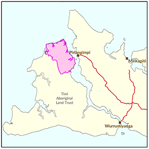
North East Bathurst Island
In 2014 the Department of Land Resource Management undertook a land suitability assessment, water resource investigation and flora and fauna evaluation in north east Bathurst Island to develop baseline information of the bio-physical resources.
The study area included 14,100ha of terrestrial land and an additional 4,700ha of intertidal environments. A total of 6,000ha were surveyed as moderately suitable for a range of crops with availability of water being a limiting factor in determining the extent and type of crops productive and economically viable.
The biodiversity assessment identified seventeen flora and fauna species listed as threatened under Northern Territory and Australian Government legislation.
Four of these species are widespread in areas assessed as suitable for agriculture.
Investors interested in development opportunities on the Tiwi Islands should contact the Land Development Corporation on 08 8944 0909.

View a larger version of the North East Bathurst Island locality map.
Development potential summary
The following reports and maps document the soil and land, water and biodiversity assets of the study area highlighting the irrigation development potential and crops most suited to the study area.
- Read the reports on the Territory Stories website.
- View the map (pdf).
- View the survey location on NR Maps.
Soil and land
The following reports and maps document the soil and land assets of the study area.
- Read the report on the Territory Stories website.
- View the map (pdf).
- Download the spatial data package.
- View the metadata.
- View the survey location on NR Maps.
Water
- View the spatial data package.
- View the metadata.
Contact
For further information contact:
Simon Cruickshank
Phone: 08 8999 3676
Email: simon.cruickshank@nt.gov.au
Give feedback about this page.
Share this page:
URL copied!